


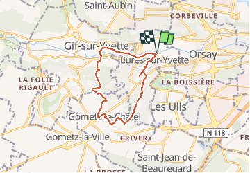
2016-12-21 Rando Bures sur Yvette

jchezlemas
User

Length
11.3 km

Max alt
174 m

Uphill gradient
244 m
Km-Effort
14.5 km

Min alt
59 m

Downhill gradient
243 m
Boucle
Yes
Creation date :
2016-12-21 00:00:00.0
Updated on :
2016-12-21 00:00:00.0
3h07
Difficulty : Easy

FREE GPS app for hiking
 SityTrail
IGN / Geographical institutes
SityTrail Plus
The world is yours!
About
Trail Walking of 11.3 km to be discovered at Ile-de-France, Essonne, Bures-sur-Yvette. This trail is proposed by jchezlemas.
Description
Rando de Martine et Alain Gauthier
Office de Tourisme de l'Arpajonnais
http://ot-arpajonnais.fr/
Positioning
Country:
France
Region :
Ile-de-France
Department/Province :
Essonne
Municipality :
Bures-sur-Yvette
Location:
Unknown
Start:(Dec)
Start:(UTM)
438533 ; 5394353 (31U) N.
Comments