Trail Other activity Acquigny - Haute - Normandie - Ligne 371 - Évreux-Embranchement - Acquigny 1 - Photo

Haute - Normandie - Ligne 371 - Évreux-Embranchement - Acquigny 1

 mich54
mich54

User

© OpenStreetMap contributors
Length
Length
11.6 km
Max alt
Max alt
47 m
Uphill gradient
Uphill gradient
78 m
Km-Effort
Km-Effort  
12.6 km
Min alt
Min alt
17 m
Downhill gradient
Downhill gradient
55 m
Boucle
Boucle
No
Creation date :
2016-12-22 00:00:00.0
Updated on :
2016-12-22 00:00:00.0

(0 Reviews)

Other activity
Other activity
5m
Difficulty : Unknown

Scan this QR Code to open this trail in the SityTrail application

FREE GPS app for hiking

Logo SityTrail SityTrail

IGN / Geographical institutes

Download SityTrail from the App Store Download SityTrail from Google Play

Logo SityTrail SityTrail Plus

The world is yours!

Download SityTrail from the App Store Download SityTrail from Google Play Download SityTrail on Huawei AppGallery

About

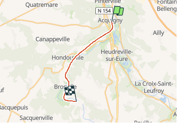
Trail Other activity of 11.6 km to be discovered at Normandy, Eure, Acquigny. This trail is proposed by mich54.

Description

La ligne d'Évreux-Embranchement à Acquigny est une ligne de chemin de fer française établie dans le département de l'Eure en région Haute-Normandie.
Elle constitue la ligne 371 0001 du réseau ferré national.
Fermeture au service pour les voyageurs le 1er mars 1940.5source Wikipédia)
Partie 1 de Acquigny à Tourneville, pas de trace visible jusque Gravigny(voir partie 2).

Elevation profile

Positioning

Country:
France
Region :
Normandy
Department/Province :
Eure
Municipality :
Acquigny
Location:
Unknown
Start:(UTM)
367330 ; 5448073 (31U) N.


Close
My subscriptions