


bondues

jeanluc59
User
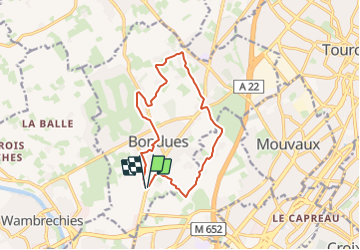

Length
11.3 km

Max alt
45 m

Uphill gradient
78 m
Km-Effort
12.3 km

Min alt
19 m

Downhill gradient
78 m
Boucle
Yes
Creation date :
2016-12-22 00:00:00.0
Updated on :
2023-07-24 08:39:49.567
2h44
Difficulty : Easy

FREE GPS app for hiking
 SityTrail
IGN / Geographical institutes
SityTrail Plus
The world is yours!
About
Trail Walking of 11.3 km to be discovered at Hauts-de-France, Nord, Bondues. This trail is proposed by jeanluc59.
Description
départ du fort de bondues
Positioning
Country:
France
Region :
Hauts-de-France
Department/Province :
Nord
Municipality :
Bondues
Location:
Unknown
Start:(Dec)
Start:(UTM)
506247 ; 5615733 (31U) N.
Comments
super