


PUGET THENIERS FOURTAS SENTIER PALUDE

ccrelais
User
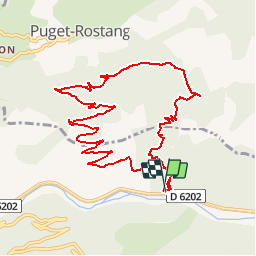

Length
11.5 km

Max alt
1096 m

Uphill gradient
733 m
Km-Effort
21 km

Min alt
383 m

Downhill gradient
733 m
Boucle
Yes
Creation date :
2016-12-26 00:00:00.0
Updated on :
2016-12-26 00:00:00.0
--
Difficulty : Unknown

FREE GPS app for hiking
 SityTrail
IGN / Geographical institutes
SityTrail Plus
The world is yours!
About
Trail Mountain bike of 11.5 km to be discovered at Provence-Alpes-Côte d'Azur, Maritime Alps, Puget-Théniers. This trail is proposed by ccrelais.
Positioning
Country:
France
Region :
Provence-Alpes-Côte d'Azur
Department/Province :
Maritime Alps
Municipality :
Puget-Théniers
Location:
Unknown
Start:(Dec)
Start:(UTM)
334199 ; 4868849 (32T) N.
Comments