


Nobressart

gue
User
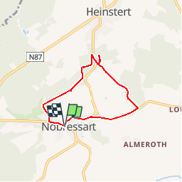

Length
5.1 km

Max alt
433 m

Uphill gradient
126 m
Km-Effort
6.7 km

Min alt
337 m

Downhill gradient
129 m
Boucle
Yes
Creation date :
2017-01-08 00:00:00.0
Updated on :
2017-01-08 00:00:00.0
--
Difficulty : Very easy

FREE GPS app for hiking
 SityTrail
IGN / Geographical institutes
SityTrail Plus
The world is yours!
About
Trail Walking of 5.1 km to be discovered at Wallonia, Luxembourg, Attert. This trail is proposed by gue.
Positioning
Country:
Belgium
Region :
Wallonia
Department/Province :
Luxembourg
Municipality :
Attert
Location:
Nobressart
Start:(Dec)
Start:(UTM)
695824 ; 5513265 (31U) N.
Comments