


c2pa - Lac de Laragou - rive sud

arnoultjf
User
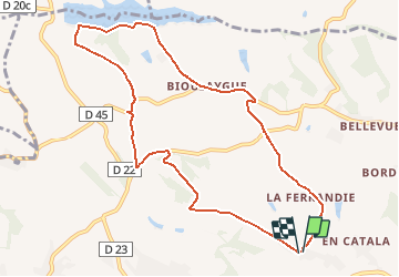

Length
10.4 km

Max alt
252 m

Uphill gradient
195 m
Km-Effort
13 km

Min alt
171 m

Downhill gradient
193 m
Boucle
Yes
Creation date :
2017-01-19 00:00:00.0
Updated on :
2017-01-19 00:00:00.0
2h30
Difficulty : Easy

FREE GPS app for hiking
 SityTrail
IGN / Geographical institutes
SityTrail Plus
The world is yours!
About
Trail Walking of 10.4 km to be discovered at Occitania, Haute-Garonne, Verfeil. This trail is proposed by arnoultjf.
Description
Départ de et retour à "En Frances"
Positioning
Country:
France
Region :
Occitania
Department/Province :
Haute-Garonne
Municipality :
Verfeil
Location:
Unknown
Start:(Dec)
Start:(UTM)
394197 ; 4835774 (31T) N.
Comments