


Asnières 27 le22012017

Laurent53
User
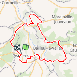

Length
19.3 km

Max alt
163 m

Uphill gradient
266 m
Km-Effort
23 km

Min alt
84 m

Downhill gradient
265 m
Boucle
Yes
Creation date :
2017-01-26 00:00:00.0
Updated on :
2017-01-26 00:00:00.0
5h28
Difficulty : Easy

FREE GPS app for hiking
 SityTrail
IGN / Geographical institutes
SityTrail Plus
The world is yours!
About
Trail Walking of 19.3 km to be discovered at Normandy, Eure, Asnières. This trail is proposed by Laurent53.


Positioning
Country:
France
Region :
Normandy
Department/Province :
Eure
Municipality :
Asnières
Location:
Unknown
Start:(Dec)
Start:(UTM)
310398 ; 5452537 (31U) N.
Comments