


thueyts le prat

raab
User
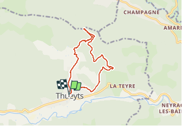

Length
6.8 km

Max alt
716 m

Uphill gradient
260 m
Km-Effort
10.3 km

Min alt
470 m

Downhill gradient
258 m
Boucle
Yes
Creation date :
2018-07-30 16:23:32.327
Updated on :
2018-07-30 16:23:32.347
2h04
Difficulty : Medium

FREE GPS app for hiking
 SityTrail
IGN / Geographical institutes
SityTrail Plus
The world is yours!
About
Trail Walking of 6.8 km to be discovered at Auvergne-Rhône-Alpes, Ardèche, Thueyts. This trail is proposed by raab.
Positioning
Country:
France
Region :
Auvergne-Rhône-Alpes
Department/Province :
Ardèche
Municipality :
Thueyts
Location:
Unknown
Start:(Dec)
Start:(UTM)
596810 ; 4947605 (31T) N.
Comments