


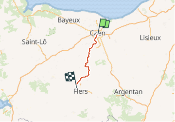
Basse Normandie - Ligne 412 - Caen - Cerisy-Belle-Etoile

mich54
User


5m
Difficulty : Unknown

FREE GPS app for hiking
 SityTrail
IGN / Geographical institutes
SityTrail Plus
The world is yours!
About
Trail Other activity of 60 km to be discovered at Normandy, Calvados, Caen. This trail is proposed by mich54.
Description
La ligne de Caen à Cerisy-Belle-Étoile, parfois appelée ligne de Caen à Flers, est une ligne française de chemin de fer à écartement standard non exploitée du réseau ferré national. Elle relie Caen à Flers en Normandie. Ce tronçon de l'axe Caen - Laval fut construit afin de désenclaver la ville en voie d'industrialisation de Condé-sur-Noireau. Cette ligne bénéficie d'un environnement paysager remarquable offert par la Suisse normande.
Fermeture au service voyageurs : 31 mai 1970 : Fermeture au service voyageurs de la ligne Caen - Cerisy-Belle-Étoile.(Source Wikipédia)
Positioning
Comments