


La Garde Adhemar_22-01-17

ajasse
User
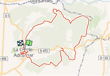

Length
13.4 km

Max alt
233 m

Uphill gradient
320 m
Km-Effort
17.7 km

Min alt
84 m

Downhill gradient
320 m
Boucle
Yes
Creation date :
2017-01-23 00:00:00.0
Updated on :
2017-01-23 00:00:00.0
4h52
Difficulty : Unknown

FREE GPS app for hiking
 SityTrail
IGN / Geographical institutes
SityTrail Plus
The world is yours!
About
Trail Other activity of 13.4 km to be discovered at Auvergne-Rhône-Alpes, Drôme, La Garde-Adhémar. This trail is proposed by ajasse.
Positioning
Country:
France
Region :
Auvergne-Rhône-Alpes
Department/Province :
Drôme
Municipality :
La Garde-Adhémar
Location:
Unknown
Start:(Dec)
Start:(UTM)
639719 ; 4917154 (31T) N.
Comments