


2011-07-07 19h11m19

Tetraneon
User
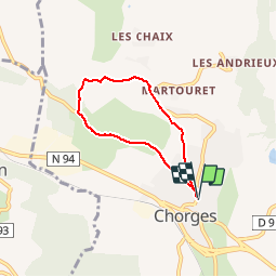

Length
5.5 km

Max alt
1029 m

Uphill gradient
168 m
Km-Effort
7.7 km

Min alt
862 m

Downhill gradient
168 m
Boucle
Yes
Creation date :
2014-12-10 00:00:00.0
Updated on :
2014-12-10 00:00:00.0
--
Difficulty : Very easy

FREE GPS app for hiking
 SityTrail
IGN / Geographical institutes
SityTrail Plus
The world is yours!
About
Trail Walking of 5.5 km to be discovered at Provence-Alpes-Côte d'Azur, Hautes-Alpes, Chorges. This trail is proposed by Tetraneon.
Positioning
Country:
France
Region :
Provence-Alpes-Côte d'Azur
Department/Province :
Hautes-Alpes
Municipality :
Chorges
Location:
Unknown
Start:(Dec)
Start:(UTM)
283735 ; 4936237 (32T) N.
Comments
Assez exposé au soleil mais très agréable...