


AU DESSUS DE MENTHON

COMAN
User

Length
5.6 km

Max alt
809 m

Uphill gradient
325 m
Km-Effort
9.9 km

Min alt
541 m

Downhill gradient
328 m
Boucle
Yes
Creation date :
2017-01-28 00:00:00.0
Updated on :
2017-01-28 00:00:00.0
2h02
Difficulty : Easy

FREE GPS app for hiking
 SityTrail
IGN / Geographical institutes
SityTrail Plus
The world is yours!
About
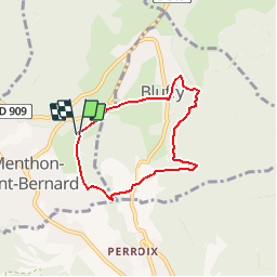
Trail Walking of 5.6 km to be discovered at Auvergne-Rhône-Alpes, Upper Savoy, Menthon-Saint-Bernard. This trail is proposed by COMAN.
Description
Au dessus du châateau de Menthon saint Bernard
Positioning
Country:
France
Region :
Auvergne-Rhône-Alpes
Department/Province :
Upper Savoy
Municipality :
Menthon-Saint-Bernard
Location:
Unknown
Start:(Dec)
Start:(UTM)
283006 ; 5082742 (32T) N.
Comments