


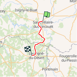
Basse Normandie - Ligne 448 - Saint-Hilaire-du-Harcouët - Fougères

mich54
User


5m
Difficulty : Unknown

FREE GPS app for hiking
 SityTrail
IGN / Geographical institutes
SityTrail Plus
The world is yours!
About
Trail Other activity of 17.2 km to be discovered at Normandy, Manche, Grandparigny. This trail is proposed by mich54.
Description
La ligne de Saint-Hilaire-du-Harcouët à Fougères est une ancienne ligne de chemin de fer française, se trouvant dans les départements de la Manche en Basse-Normandie et d'Ille-et-Vilaine en Bretagne. Elle reliait Saint-Hilaire-du-Harcouët à Fougères.À la suite de la création de la SNCF, la ligne est fermée au trafic voyageur le 10 octobre 1938.
Section de Saint-Hilaire-du-Harcouët à Louvigné-du-Désert.
Positioning
Comments