


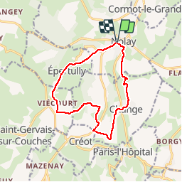
X - 2017 - 33 Nolay Mont de Rème

clabidault
User

Length
12.5 km

Max alt
510 m

Uphill gradient
321 m
Km-Effort
16.8 km

Min alt
284 m

Downhill gradient
321 m
Boucle
Yes
Creation date :
2018-02-26 00:00:00.0
Updated on :
2019-01-03 20:56:56.251
3h55
Difficulty : Medium

FREE GPS app for hiking
 SityTrail
IGN / Geographical institutes
SityTrail Plus
The world is yours!
About
Trail Walking of 12.5 km to be discovered at Bourgogne-Franche-Comté, Côte-d'Or, Nolay. This trail is proposed by clabidault.
Positioning
Country:
France
Region :
Bourgogne-Franche-Comté
Department/Province :
Côte-d'Or
Municipality :
Nolay
Location:
Unknown
Start:(Dec)
Start:(UTM)
624055 ; 5201028 (31T) N.
Comments