Trail Walking Plainfaing - chemin du page - Photo
 papiou
papiou

User

© OpenStreetMap contributors
Length
Length
9.7 km
Max alt
Max alt
979 m
Uphill gradient
Uphill gradient
357 m
Km-Effort
Km-Effort  
14.4 km
Min alt
Min alt
637 m
Downhill gradient
Downhill gradient
354 m
Boucle
Boucle
Yes
Creation date :
2017-02-02 00:00:00.0
Updated on :
2017-02-02 00:00:00.0

(0 Reviews)

Walking
Walking
2h24
Difficulty : Medium

Scan this QR Code to open this trail in the SityTrail application

FREE GPS app for hiking

Logo SityTrail SityTrail

IGN / Geographical institutes

Download SityTrail from the App Store Download SityTrail from Google Play

Logo SityTrail SityTrail Plus

The world is yours!

Download SityTrail from the App Store Download SityTrail from Google Play Download SityTrail on Huawei AppGallery

About

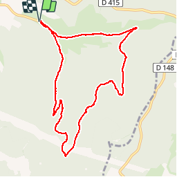
Trail Walking of 9.7 km to be discovered at Grand Est, Vosges, Plainfaing. This trail is proposed by papiou.

Description

Rdv Baracon ,se garer près centrale. partir vers la montagne puis prendre légèrement sur la droite vers chaume. à la fin du Macadam et à côté d'un petit pont prendre à gauche et entrer dans forêt des hospices qui monte en lacets, passer 2 fois sous lignes EDF puis dans un virage aller tout droit par le chemin du page qui rejoint l'ancienne route du col qu'il faut redescendre jusqu'au point de départ.

Elevation profile

Positioning

Country:
France
Region :
Grand Est
Department/Province :
Vosges
Municipality :
Plainfaing
Location:
Unknown
Start:(UTM)
354431 ; 5336531 (32U) N.


Close
My subscriptions