


tour du bois de la reynarde

Coryphene
User
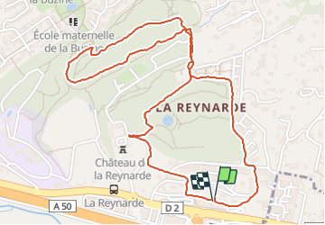

Length
3.3 km

Max alt
136 m

Uphill gradient
77 m
Km-Effort
4.4 km

Min alt
79 m

Downhill gradient
77 m
Boucle
Yes
Creation date :
2017-02-06 00:00:00.0
Updated on :
2017-02-06 00:00:00.0
42m
Difficulty : Unknown

FREE GPS app for hiking
 SityTrail
IGN / Geographical institutes
SityTrail Plus
The world is yours!
About
Trail Other activity of 3.3 km to be discovered at Provence-Alpes-Côte d'Azur, Bouches-du-Rhône, Marseille. This trail is proposed by Coryphene.
Positioning
Country:
France
Region :
Provence-Alpes-Côte d'Azur
Department/Province :
Bouches-du-Rhône
Municipality :
Marseille
Location:
11th Arrondissement
Start:(Dec)
Start:(UTM)
703628 ; 4795868 (31T) N.
Comments