


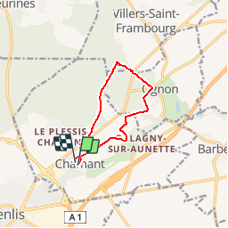
Balagny variante 8.6 KM

GOELERANDO2
User

Length
8.6 km

Max alt
110 m

Uphill gradient
104 m
Km-Effort
9.9 km

Min alt
66 m

Downhill gradient
101 m
Boucle
Yes
Creation date :
2017-02-08 00:00:00.0
Updated on :
2017-02-08 00:00:00.0
2h10
Difficulty : Medium

FREE GPS app for hiking
 SityTrail
IGN / Geographical institutes
SityTrail Plus
The world is yours!
About
Trail Walking of 8.6 km to be discovered at Hauts-de-France, Oise, Chamant. This trail is proposed by GOELERANDO2.
Description
Départ et Parking à la Mairie de Balagny sur l'Aunette (60)
Positioning
Country:
France
Region :
Hauts-de-France
Department/Province :
Oise
Municipality :
Chamant
Location:
Unknown
Start:(Dec)
Start:(UTM)
471764 ; 5451850 (31U) N.
Comments