


LL34 St Félix de l'Héras (long)

alainandrejoly
User
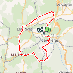

Length
17.3 km

Max alt
814 m

Uphill gradient
349 m
Km-Effort
22 km

Min alt
626 m

Downhill gradient
350 m
Boucle
Yes
Creation date :
2017-02-18 00:00:00.0
Updated on :
2017-02-18 00:00:00.0
5h20
Difficulty : Medium

FREE GPS app for hiking
 SityTrail
IGN / Geographical institutes
SityTrail Plus
The world is yours!
About
Trail Walking of 17.3 km to be discovered at Occitania, Hérault, Saint-Félix-de-l'Héras. This trail is proposed by alainandrejoly.
Description
18/02/2017
Positioning
Country:
France
Region :
Occitania
Department/Province :
Hérault
Municipality :
Saint-Félix-de-l'Héras
Location:
Unknown
Start:(Dec)
Start:(UTM)
523583 ; 4853727 (31T) N.
Comments