


gerberoy

LaHAL
User
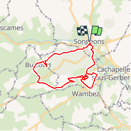

Length
12.9 km

Max alt
210 m

Uphill gradient
288 m
Km-Effort
16.7 km

Min alt
110 m

Downhill gradient
288 m
Boucle
Yes
Creation date :
2017-02-18 00:00:00.0
Updated on :
2017-02-18 00:00:00.0
--
Difficulty : Medium

FREE GPS app for hiking
 SityTrail
IGN / Geographical institutes
SityTrail Plus
The world is yours!
About
Trail Walking of 12.9 km to be discovered at Hauts-de-France, Oise, Songeons. This trail is proposed by LaHAL.
Positioning
Country:
France
Region :
Hauts-de-France
Department/Province :
Oise
Municipality :
Songeons
Location:
Unknown
Start:(Dec)
Start:(UTM)
417068 ; 5489158 (31U) N.
Comments
bois de caumont difficile à traverser