


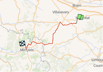
GR78 - Etape 2 - Montréal-Mirepoix

patoche2009
User

Length
34 km

Max alt
454 m

Uphill gradient
810 m
Km-Effort
45 km

Min alt
188 m

Downhill gradient
693 m
Boucle
No
Creation date :
2017-02-26 00:00:00.0
Updated on :
2017-02-26 00:00:00.0
9h22
Difficulty : Easy

FREE GPS app for hiking
 SityTrail
IGN / Geographical institutes
SityTrail Plus
The world is yours!
About
Trail Walking of 34 km to be discovered at Occitania, Aude, Villeneuve-lès-Montréal. This trail is proposed by patoche2009.
Description
Voir étape 1 Carcassonne - Ville neuve les Montréal
Positioning
Country:
France
Region :
Occitania
Department/Province :
Aude
Municipality :
Villeneuve-lès-Montréal
Location:
Unknown
Start:(Dec)
Start:(UTM)
427869 ; 4781216 (31T) N.
Comments