


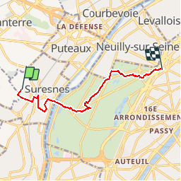
Mont Valérien 8.4 km

GOELERANDO2
User

Length
8.4 km

Max alt
124 m

Uphill gradient
66 m
Km-Effort
9.6 km

Min alt
28 m

Downhill gradient
153 m
Boucle
No
Creation date :
2017-02-22 00:00:00.0
Updated on :
2017-02-22 00:00:00.0
2h03
Difficulty : Medium

FREE GPS app for hiking
 SityTrail
IGN / Geographical institutes
SityTrail Plus
The world is yours!
About
Trail Walking of 8.4 km to be discovered at Ile-de-France, Hauts-de-Seine, Suresnes. This trail is proposed by GOELERANDO2.
Description
Départ du Mont Valérien vers la Porte Maillot par le Bois de Boulogne.
Positioning
Country:
France
Region :
Ile-de-France
Department/Province :
Hauts-de-Seine
Municipality :
Suresnes
Location:
Unknown
Start:(Dec)
Start:(UTM)
442319 ; 5413406 (31U) N.
Comments