


Le Mazaud

viam19
User
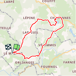

Length
15.1 km

Max alt
831 m

Uphill gradient
306 m
Km-Effort
19.2 km

Min alt
741 m

Downhill gradient
306 m
Boucle
Yes
Creation date :
2017-02-22 00:00:00.0
Updated on :
2017-02-22 00:00:00.0
4h05
Difficulty : Easy

FREE GPS app for hiking
 SityTrail
IGN / Geographical institutes
SityTrail Plus
The world is yours!
About
Trail Walking of 15.1 km to be discovered at New Aquitaine, Corrèze, Tarnac. This trail is proposed by viam19.
Positioning
Country:
France
Region :
New Aquitaine
Department/Province :
Corrèze
Municipality :
Tarnac
Location:
Unknown
Start:(Dec)
Start:(UTM)
418134 ; 5053398 (31T) N.
Comments