


FFBMP Trois-Ponts

fra_depoorter
User

Length
12.1 km

Max alt
472 m

Uphill gradient
303 m
Km-Effort
16.2 km

Min alt
284 m

Downhill gradient
302 m
Boucle
Yes
Creation date :
2017-03-04 00:00:00.0
Updated on :
2017-03-04 00:00:00.0
2h35
Difficulty : Unknown

FREE GPS app for hiking
 SityTrail
IGN / Geographical institutes
SityTrail Plus
The world is yours!
About
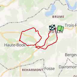
Trail Walking of 12.1 km to be discovered at Wallonia, Liège, Trois-Ponts. This trail is proposed by fra_depoorter.
Positioning
Country:
Belgium
Region :
Wallonia
Department/Province :
Liège
Municipality :
Trois-Ponts
Location:
Fosse
Start:(Dec)
Start:(UTM)
702606 ; 5583134 (31U) N.
Comments