


5 mars

rollondesbois
User
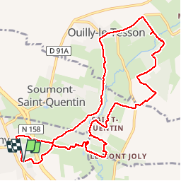

Length
11.8 km

Max alt
167 m

Uphill gradient
195 m
Km-Effort
14.4 km

Min alt
80 m

Downhill gradient
197 m
Boucle
Yes
Creation date :
2017-03-05 00:00:00.0
Updated on :
2017-03-05 00:00:00.0
3h52
Difficulty : Unknown

FREE GPS app for hiking
 SityTrail
IGN / Geographical institutes
SityTrail Plus
The world is yours!
About
Trail Walking of 11.8 km to be discovered at Normandy, Calvados, Potigny. This trail is proposed by rollondesbois.
Positioning
Country:
France
Region :
Normandy
Department/Province :
Calvados
Municipality :
Potigny
Location:
Unknown
Start:(Dec)
Start:(UTM)
702028 ; 5427585 (30U) N.
Comments