


De Thillot à St Maurice

fraxin
User
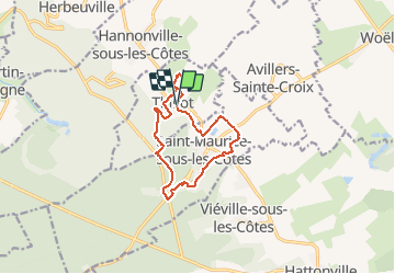

Length
10.7 km

Max alt
405 m

Uphill gradient
220 m
Km-Effort
13.7 km

Min alt
237 m

Downhill gradient
226 m
Boucle
Yes
Creation date :
2014-12-10 00:00:00.0
Updated on :
2014-12-10 00:00:00.0
2h20
Difficulty : Easy

FREE GPS app for hiking
 SityTrail
IGN / Geographical institutes
SityTrail Plus
The world is yours!
About
Trail Walking of 10.7 km to be discovered at Grand Est, Meuse, Thillot. This trail is proposed by fraxin.


Positioning
Country:
France
Region :
Grand Est
Department/Province :
Meuse
Municipality :
Thillot
Location:
Unknown
Start:(Dec)
Start:(UTM)
695193 ; 5433761 (31U) N.
Comments