


La Roche Guyon 6.3 km

GOELERANDO2
User
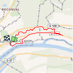

Length
6.3 km

Max alt
116 m

Uphill gradient
147 m
Km-Effort
8.3 km

Min alt
16 m

Downhill gradient
145 m
Boucle
Yes
Creation date :
2017-03-13 00:00:00.0
Updated on :
2017-03-13 00:00:00.0
1h44
Difficulty : Difficult

FREE GPS app for hiking
 SityTrail
IGN / Geographical institutes
SityTrail Plus
The world is yours!
About
Trail Walking of 6.3 km to be discovered at Ile-de-France, Val-d'Oise, La Roche-Guyon. This trail is proposed by GOELERANDO2.
Description
Du parking en suivant le GR2 et retour par Haute Isle.
Positioning
Country:
France
Region :
Ile-de-France
Department/Province :
Val-d'Oise
Municipality :
La Roche-Guyon
Location:
Unknown
Start:(Dec)
Start:(UTM)
399742 ; 5437156 (31U) N.
Comments