


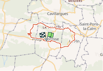
Pougnadoresse - Le Pin - Chapelle St Jean

GOIOLIRIBES
User

Length
13.3 km

Max alt
252 m

Uphill gradient
252 m
Km-Effort
16.6 km

Min alt
109 m

Downhill gradient
254 m
Boucle
Yes
Creation date :
2014-12-10 00:00:00.0
Updated on :
2025-03-12 12:56:37.559
3h46
Difficulty : Difficult

FREE GPS app for hiking
 SityTrail
IGN / Geographical institutes
SityTrail Plus
The world is yours!
About
Trail Walking of 13.3 km to be discovered at Occitania, Gard, Pougnadoresse. This trail is proposed by GOIOLIRIBES.
Description
Départ du cimetière de Pougnadoresse.
Positioning
Country:
France
Region :
Occitania
Department/Province :
Gard
Municipality :
Pougnadoresse
Location:
Unknown
Start:(Dec)
Start:(UTM)
620651 ; 4883050 (31T) N.
Comments