


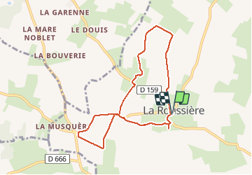
La Roussière

werth
User

Length
7.5 km

Max alt
206 m

Uphill gradient
36 m
Km-Effort
8 km

Min alt
193 m

Downhill gradient
36 m
Boucle
Yes
Creation date :
2017-03-14 00:00:00.0
Updated on :
2017-03-14 00:00:00.0
2h08
Difficulty : Easy

FREE GPS app for hiking
 SityTrail
IGN / Geographical institutes
SityTrail Plus
The world is yours!
About
Trail Walking of 7.5 km to be discovered at Normandy, Eure, Mesnil-en-Ouche. This trail is proposed by werth.
Description
monotone avec beaucoup de routes et champs
Positioning
Country:
France
Region :
Normandy
Department/Province :
Eure
Municipality :
Mesnil-en-Ouche
Location:
La Roussière
Start:(Dec)
Start:(UTM)
322881 ; 5425898 (31U) N.
Comments