


19.03.2017-l'lll Wald - Selestat

delm
User
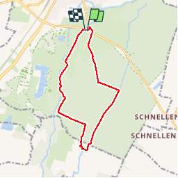

Length
12 km

Max alt
184 m

Uphill gradient
91 m
Km-Effort
13.2 km

Min alt
163 m

Downhill gradient
91 m
Boucle
Yes
Creation date :
2017-03-19 00:00:00.0
Updated on :
2017-03-19 00:00:00.0
2h33
Difficulty : Very easy

FREE GPS app for hiking
 SityTrail
IGN / Geographical institutes
SityTrail Plus
The world is yours!
About
Trail Walking of 12 km to be discovered at Grand Est, Bas-Rhin, Sélestat. This trail is proposed by delm.
Description
Belle randonnée facile
Positioning
Country:
France
Region :
Grand Est
Department/Province :
Bas-Rhin
Municipality :
Sélestat
Location:
Unknown
Start:(Dec)
Start:(UTM)
385578 ; 5344836 (32U) N.
Comments
Randonnée très agréable sauf certains passages boueux en cette période printanière.