


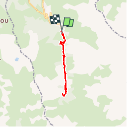
valmeinier lac vert

brn66
User

Length
11.7 km

Max alt
1995 m

Uphill gradient
430 m
Km-Effort
17.4 km

Min alt
1657 m

Downhill gradient
418 m
Boucle
Yes
Creation date :
2017-03-19 00:00:00.0
Updated on :
2017-03-19 00:00:00.0
4h12
Difficulty : Unknown

FREE GPS app for hiking
 SityTrail
IGN / Geographical institutes
SityTrail Plus
The world is yours!
About
Trail Other activity of 11.7 km to be discovered at Auvergne-Rhône-Alpes, Savoy, Valmeinier. This trail is proposed by brn66.
Positioning
Country:
France
Region :
Auvergne-Rhône-Alpes
Department/Province :
Savoy
Municipality :
Valmeinier
Location:
Unknown
Start:(Dec)
Start:(UTM)
302997 ; 5005110 (32T) N.
Comments