


concots VTT option 2

cps46
User
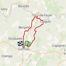

Length
22 km

Max alt
380 m

Uphill gradient
559 m
Km-Effort
30 km

Min alt
140 m

Downhill gradient
559 m
Boucle
Yes
Creation date :
2017-03-24 00:00:00.0
Updated on :
2017-03-24 00:00:00.0
2h14
Difficulty : Easy

FREE GPS app for hiking
 SityTrail
IGN / Geographical institutes
SityTrail Plus
The world is yours!
About
Trail Mountain bike of 22 km to be discovered at Occitania, Lot, Concots. This trail is proposed by cps46.
Positioning
Country:
France
Region :
Occitania
Department/Province :
Lot
Municipality :
Concots
Location:
Unknown
Start:(Dec)
Start:(UTM)
392070 ; 4917326 (31T) N.
Comments