Mélinières 12,5

yago1404
User GUIDE
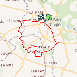

Length
12.5 km

Max alt
121 m

Uphill gradient
80 m
Km-Effort
13.6 km

Min alt
98 m

Downhill gradient
80 m
Boucle
Yes
Creation date :
2017-03-26 00:00:00.0
Updated on :
2017-03-26 00:00:00.0
2h09
Difficulty : Easy

FREE GPS app for hiking
 SityTrail
IGN / Geographical institutes
SityTrail Plus
The world is yours!
About
Trail Nordic walking of 12.5 km to be discovered at Brittany, Ille-et-Vilaine, Maen-Roch. This trail is proposed by yago1404.
Positioning
Country:
France
Region :
Brittany
Department/Province :
Ille-et-Vilaine
Municipality :
Maen-Roch
Location:
Saint-Brice-en-Coglès
Start:(Dec)
Start:(UTM)
620355 ; 5363068 (30U) N.
Comments