


260327_5_Cha_Par_Dar

d.rognon
User
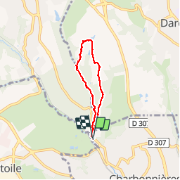

Length
5 km

Max alt
306 m

Uphill gradient
69 m
Km-Effort
5.9 km

Min alt
244 m

Downhill gradient
67 m
Boucle
Yes
Creation date :
2017-03-26 00:00:00.0
Updated on :
2017-03-26 00:00:00.0
1h56
Difficulty : Unknown

FREE GPS app for hiking
 SityTrail
IGN / Geographical institutes
SityTrail Plus
The world is yours!
About
Trail Walking of 5 km to be discovered at Auvergne-Rhône-Alpes, Métropole de Lyon, Charbonnières-les-Bains. This trail is proposed by d.rognon.
Positioning
Country:
France
Region :
Auvergne-Rhône-Alpes
Department/Province :
Métropole de Lyon
Municipality :
Charbonnières-les-Bains
Location:
Unknown
Start:(Dec)
Start:(UTM)
634674 ; 5071797 (31T) N.
Comments