La chapelle Hareng

werth
User
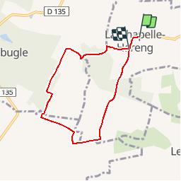

Length
6.1 km

Max alt
193 m

Uphill gradient
74 m
Km-Effort
7.1 km

Min alt
144 m

Downhill gradient
77 m
Boucle
No
Creation date :
2017-03-27 00:00:00.0
Updated on :
2017-03-27 00:00:00.0
1h40
Difficulty : Unknown

FREE GPS app for hiking
 SityTrail
IGN / Geographical institutes
SityTrail Plus
The world is yours!
About
Trail Other activity of 6.1 km to be discovered at Normandy, Eure, La Chapelle-Hareng. This trail is proposed by werth.
Positioning
Country:
France
Region :
Normandy
Department/Province :
Eure
Municipality :
La Chapelle-Hareng
Location:
Unknown
Start:(Dec)
Start:(UTM)
311342 ; 5443350 (31U) N.
Comments