


aubenasson

raygautier
User
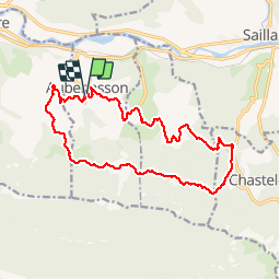

Length
16.8 km

Max alt
748 m

Uphill gradient
552 m
Km-Effort
24 km

Min alt
301 m

Downhill gradient
561 m
Boucle
Yes
Creation date :
2017-03-28 00:00:00.0
Updated on :
2017-03-28 00:00:00.0
4h38
Difficulty : Easy

FREE GPS app for hiking
 SityTrail
IGN / Geographical institutes
SityTrail Plus
The world is yours!
About
Trail Walking of 16.8 km to be discovered at Auvergne-Rhône-Alpes, Drôme, Aubenasson. This trail is proposed by raygautier.
Positioning
Country:
France
Region :
Auvergne-Rhône-Alpes
Department/Province :
Drôme
Municipality :
Aubenasson
Location:
Unknown
Start:(Dec)
Start:(UTM)
669623 ; 4950113 (31T) N.
Comments
28/01/2018 belle balade dans la neige avec des jolis paysages et un trace impeccable. À bientôt Raymond