


280317_10_Tarare

d.rognon
User
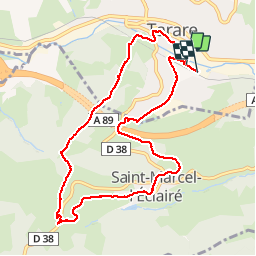

Length
10 km

Max alt
707 m

Uphill gradient
365 m
Km-Effort
14.9 km

Min alt
385 m

Downhill gradient
367 m
Boucle
Yes
Creation date :
2017-03-29 00:00:00.0
Updated on :
2017-03-29 00:00:00.0
3h55
Difficulty : Unknown

FREE GPS app for hiking
 SityTrail
IGN / Geographical institutes
SityTrail Plus
The world is yours!
About
Trail Walking of 10 km to be discovered at Auvergne-Rhône-Alpes, Rhône, Tarare. This trail is proposed by d.rognon.
Positioning
Country:
France
Region :
Auvergne-Rhône-Alpes
Department/Province :
Rhône
Municipality :
Tarare
Location:
Unknown
Start:(Dec)
Start:(UTM)
611682 ; 5082831 (31T) N.
Comments