Trail Equestrian Saint-Cyprien - bocal du Tech - Photo
© OpenStreetMap contributors
Length
Length
17 km
Max alt
Max alt
8 m
Uphill gradient
Uphill gradient
55 m
Km-Effort
Km-Effort  
17.7 km
Min alt
Min alt
-6 m
Downhill gradient
Downhill gradient
55 m
Boucle
Boucle
Yes
Creation date :
2017-03-29 00:00:00.0
Updated on :
2017-03-29 00:00:00.0

(1 Reviews)

Equestrian
Equestrian
3h20
Difficulty : Medium

Scan this QR Code to open this trail in the SityTrail application

FREE GPS app for hiking

Logo SityTrail SityTrail

IGN / Geographical institutes

Download SityTrail from the App Store Download SityTrail from Google Play

Logo SityTrail SityTrail World

The world is yours!

Download SityTrail from the App Store Download SityTrail from Google Play Download SityTrail on Huawei AppGallery

About

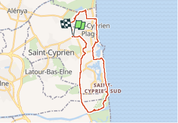
Trail Equestrian of 17 km to be discovered at Occitania, Pyrénées-Orientales, Saint-Cyprien. This trail is proposed by sandymocko.

Description

l'Andalou bocal du Tech Saint-Cyprien Sud la bande verte le golf retour

Elevation profile

Photos

Positioning

Country:
France
Region :
Occitania
Department/Province :
Pyrénées-Orientales
Municipality :
Saint-Cyprien
Location:
Unknown
Start:(UTM)
501624 ; 4719290 (31T) N.

Comments

Please log in to post a review or rate the element


super balade


Trails nearby

Trail Walking Saint-Cyprien - SAINT-CYPRIEN 66 - front de mer - les CAPELLANS - Photo
Walking
jeff66

Walking

Easy
(2)
Saint-Cyprien, Occitania, Pyrénées-Orientales, France
9.9 km | 10.3 km-effort
2h 11min
Yes
Trail Walking Saleilles - 66 SALEILLES - St-NAZAIRE, entre FOSSEILLE et REART - Photo
Walking
jeff66

Walking

Easy
(1)
Saleilles, Occitania, Pyrénées-Orientales, France
7.3 km | 7.7 km-effort
1h 8min
Yes
Trail Walking Saint-Cyprien - 66 SAINT-CYPRIEN - ALENYA - LATOUR-BAS-ELNE - de berges en berges  - Photo
Walking
jeff66

Walking

Medium
Saint-Cyprien, Occitania, Pyrénées-Orientales, France
7.9 km | 8.3 km-effort
1h 16min
Yes
Trail Walking Saint-Nazaire - 66 SAINT-NAZAIRE - CABESTANY promenade dans le vignoble de galets - Photo
Walking
jeff66

Walking

Medium
Saint-Nazaire, Occitania, Pyrénées-Orientales, France
9 km | 9.9 km-effort
1h 29min
Yes
Trail Walking Canet-en-Roussillon - CANET-EN-ROUSSILLON 66 - entre mer, plage, dunes et étang - SAINT-CYPRIEN-PLAGE - Photo
Walking
jeff66

Walking

Medium
Canet-en-Roussillon, Occitania, Pyrénées-Orientales, France
12.5 km | 12.9 km-effort
2h 14min
Yes
Trail Walking Saint-Cyprien - SAINT-CYPRIEN SUD 66 - Le bocal du TECH  - Photo
Walking
jeff66

Walking

Easy
(1)
Saint-Cyprien, Occitania, Pyrénées-Orientales, France
6.5 km | 6.8 km-effort
1h 20min
Yes
Trail Walking Argelès-sur-Mer - MAS LARRIEU - ARGELES-SUR-MER 66 - autour de la réserve naturelle, le littoral et retour par l'embouchure du TECH - Photo
Walking
jeff66

Walking

Medium
(1)
Argelès-sur-Mer, Occitania, Pyrénées-Orientales, France
13.6 km | 14.3 km-effort
2h 24min
Yes
Trail Walking Elne - ALENYA 66 - entre l'Agouille de la Mar et le Réart - Photo
Walking
jeff66

Walking

Easy
Elne, Occitania, Pyrénées-Orientales, France
12.6 km | 13.1 km-effort
1h 57min
Yes
Trail Walking Argelès-sur-Mer - réserve du mas Larrieu de part et d autre du Tech - Photo
Walking
stef789

Walking

Medium
Argelès-sur-Mer, Occitania, Pyrénées-Orientales, France
5.9 km | 6.1 km-effort
2h 12min
Yes


Close
My subscriptions