


balade 1

micheldutilleul
User
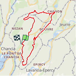

Length
19 km

Max alt
753 m

Uphill gradient
507 m
Km-Effort
26 km

Min alt
526 m

Downhill gradient
507 m
Boucle
Yes
Creation date :
2017-04-01 00:00:00.0
Updated on :
2017-04-01 00:00:00.0
4h53
Difficulty : Unknown

FREE GPS app for hiking
 SityTrail
IGN / Geographical institutes
SityTrail Plus
The world is yours!
About
Trail Walking of 19 km to be discovered at Bourgogne-Franche-Comté, Jura, Montcusel. This trail is proposed by micheldutilleul.
Positioning
Country:
France
Region :
Bourgogne-Franche-Comté
Department/Province :
Jura
Municipality :
Montcusel
Location:
Unknown
Start:(Dec)
Start:(UTM)
704458 ; 5136486 (31T) N.
Comments