Beaulieu_6.6kms

ZAMBAUX
User
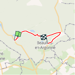

Length
6.6 km

Max alt
301 m

Uphill gradient
148 m
Km-Effort
8.4 km

Min alt
206 m

Downhill gradient
86 m
Boucle
No
Creation date :
2019-04-27 09:34:56.513
Updated on :
2019-04-27 09:34:56.556
1h52
Difficulty : Easy

FREE GPS app for hiking
 SityTrail
IGN / Geographical institutes
SityTrail Plus
The world is yours!
About
Trail Walking of 6.6 km to be discovered at Grand Est, Meuse, Beaulieu-en-Argonne. This trail is proposed by ZAMBAUX.
Positioning
Country:
France
Region :
Grand Est
Department/Province :
Meuse
Municipality :
Beaulieu-en-Argonne
Location:
Unknown
Start:(Dec)
Start:(UTM)
648330 ; 5433349 (31U) N.
Comments