


la balme de rencurel - abri de la goulandière

maupassant38
User
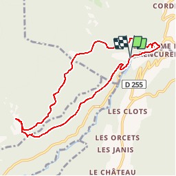

Length
8.6 km

Max alt
1085 m

Uphill gradient
469 m
Km-Effort
14.8 km

Min alt
657 m

Downhill gradient
478 m
Boucle
Yes
Creation date :
2019-02-22 22:31:06.876
Updated on :
2019-02-22 22:31:06.884
3h41
Difficulty : Medium

FREE GPS app for hiking
 SityTrail
IGN / Geographical institutes
SityTrail Plus
The world is yours!
About
Trail Walking of 8.6 km to be discovered at Auvergne-Rhône-Alpes, Isère, Rencurel. This trail is proposed by maupassant38.
Positioning
Country:
France
Region :
Auvergne-Rhône-Alpes
Department/Province :
Isère
Municipality :
Rencurel
Location:
Unknown
Start:(Dec)
Start:(UTM)
693637 ; 4995495 (31T) N.
Comments