


les boutons col de la bataille conbberoufle

guyzinz
User

Length
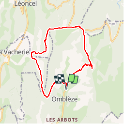
16.2 km

Max alt
1380 m

Uphill gradient
1025 m
Km-Effort
30 km

Min alt
706 m

Downhill gradient
1025 m
Boucle
Yes
Creation date :
2019-06-07 09:39:14.994
Updated on :
2019-06-07 09:39:15.162
6h06
Difficulty : Difficult

FREE GPS app for hiking
 SityTrail
IGN / Geographical institutes
SityTrail Plus
The world is yours!
About
Trail Walking of 16.2 km to be discovered at Auvergne-Rhône-Alpes, Drôme, Omblèze. This trail is proposed by guyzinz.
Positioning
Country:
France
Region :
Auvergne-Rhône-Alpes
Department/Province :
Drôme
Municipality :
Omblèze
Location:
Unknown
Start:(Dec)
Start:(UTM)
675498 ; 4970657 (31T) N.
Comments