


Ermenonville

Francine
User
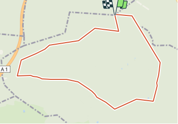

Length
10.1 km

Max alt
120 m

Uphill gradient
125 m
Km-Effort
11.7 km

Min alt
68 m

Downhill gradient
124 m
Boucle
Yes
Creation date :
2017-04-18 00:00:00.0
Updated on :
2017-04-18 00:00:00.0
2h00
Difficulty : Easy

FREE GPS app for hiking
 SityTrail
IGN / Geographical institutes
SityTrail Plus
The world is yours!
About
Trail Nordic walking of 10.1 km to be discovered at Hauts-de-France, Oise, Mont-l'Évêque. This trail is proposed by Francine.
Description
Ermenonville
Positioning
Country:
France
Region :
Hauts-de-France
Department/Province :
Oise
Municipality :
Mont-l'Évêque
Location:
Unknown
Start:(Dec)
Start:(UTM)
473176 ; 5446513 (31U) N.
Comments