


Castellar-Roc d'Orméa 18-04-2017

fredetpascale
User GUIDE
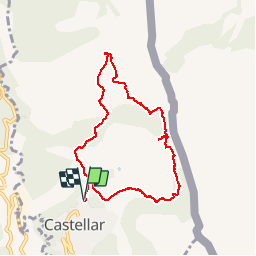

Length
8.6 km

Max alt
1107 m

Uphill gradient
770 m
Km-Effort
18.8 km

Min alt
347 m

Downhill gradient
762 m
Boucle
Yes
Creation date :
2017-04-18 00:00:00.0
Updated on :
2017-04-18 00:00:00.0
3h07
Difficulty : Medium

FREE GPS app for hiking
 SityTrail
IGN / Geographical institutes
SityTrail Plus
The world is yours!
About
Trail Walking of 8.6 km to be discovered at Provence-Alpes-Côte d'Azur, Maritime Alps, Castellar. This trail is proposed by fredetpascale.
Positioning
Country:
France
Region :
Provence-Alpes-Côte d'Azur
Department/Province :
Maritime Alps
Municipality :
Castellar
Location:
Unknown
Start:(Dec)
Start:(UTM)
379254 ; 4851571 (32T) N.
Comments