


Larressingle Eauze

norihtom
User
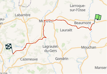

Length
24 km

Max alt
168 m

Uphill gradient
349 m
Km-Effort
29 km

Min alt
79 m

Downhill gradient
346 m
Boucle
No
Creation date :
2017-05-14 00:00:00.0
Updated on :
2017-05-14 00:00:00.0
6h15
Difficulty : Unknown

FREE GPS app for hiking
 SityTrail
IGN / Geographical institutes
SityTrail Plus
The world is yours!
About
Trail Walking of 24 km to be discovered at Occitania, Gers, Larressingle. This trail is proposed by norihtom.
Positioning
Country:
France
Region :
Occitania
Department/Province :
Gers
Municipality :
Larressingle
Location:
Unknown
Start:(Dec)
Start:(UTM)
284338 ; 4869180 (31T) N.
Comments