


st eloi

dehemjacques
User

Length
10.5 km

Max alt
151 m

Uphill gradient
171 m
Km-Effort
12.8 km

Min alt
76 m

Downhill gradient
172 m
Boucle
Yes
Creation date :
2017-04-20 00:00:00.0
Updated on :
2017-04-20 00:00:00.0
1h56
Difficulty : Medium

FREE GPS app for hiking
 SityTrail
IGN / Geographical institutes
SityTrail Plus
The world is yours!
About
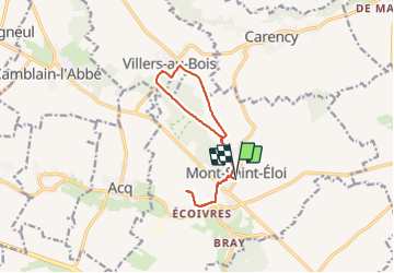
Trail Nordic walking of 10.5 km to be discovered at Hauts-de-France, Pas-de-Calais, Mont-Saint-Éloi. This trail is proposed by dehemjacques.
Positioning
Country:
France
Region :
Hauts-de-France
Department/Province :
Pas-de-Calais
Municipality :
Mont-Saint-Éloi
Location:
Unknown
Start:(Dec)
Start:(UTM)
478110 ; 5577630 (31U) N.
Comments