


20220623-Le Havre A-M

doudet
User
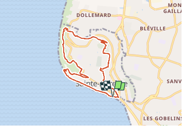

Length
8 km

Max alt
97 m

Uphill gradient
205 m
Km-Effort
10.7 km

Min alt
2 m

Downhill gradient
206 m
Boucle
Yes
Creation date :
2018-09-11 09:11:06.186
Updated on :
2022-06-20 06:28:16.233
2h49
Difficulty : Unknown

FREE GPS app for hiking
 SityTrail
IGN / Geographical institutes
SityTrail Plus
The world is yours!
About
Trail Walking of 8 km to be discovered at Normandy, Seine-Maritime, Sainte-Adresse. This trail is proposed by doudet.
Positioning
Country:
France
Region :
Normandy
Department/Province :
Seine-Maritime
Municipality :
Sainte-Adresse
Location:
Unknown
Start:(Dec)
Start:(UTM)
288916 ; 5487378 (31U) N.
Comments