


FFBMP Stavelot

fra_depoorter
User
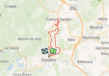

Length
22 km

Max alt
549 m

Uphill gradient
486 m
Km-Effort
28 km

Min alt
295 m

Downhill gradient
485 m
Boucle
Yes
Creation date :
2017-04-22 00:00:00.0
Updated on :
2017-04-22 00:00:00.0
4h42
Difficulty : Unknown

FREE GPS app for hiking
 SityTrail
IGN / Geographical institutes
SityTrail Plus
The world is yours!
About
Trail Walking of 22 km to be discovered at Wallonia, Liège, Stavelot. This trail is proposed by fra_depoorter.
Positioning
Country:
Belgium
Region :
Wallonia
Department/Province :
Liège
Municipality :
Stavelot
Location:
Stavelot
Start:(Dec)
Start:(UTM)
708336 ; 5586928 (31U) N.
Comments