


Genholac

ajasse
User
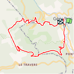

Length
11.6 km

Max alt
899 m

Uphill gradient
512 m
Km-Effort
18.4 km

Min alt
448 m

Downhill gradient
516 m
Boucle
Yes
Creation date :
2017-04-25 00:00:00.0
Updated on :
2017-04-25 00:00:00.0
4h10
Difficulty : Unknown

FREE GPS app for hiking
 SityTrail
IGN / Geographical institutes
SityTrail Plus
The world is yours!
About
Trail Other activity of 11.6 km to be discovered at Occitania, Gard, Génolhac. This trail is proposed by ajasse.
Positioning
Country:
France
Region :
Occitania
Department/Province :
Gard
Municipality :
Génolhac
Location:
Unknown
Start:(Dec)
Start:(UTM)
575834 ; 4910890 (31T) N.
Comments