


ESCOUSSENS

CANON2
User
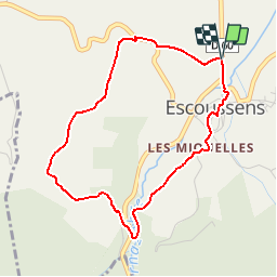

Length
4.2 km

Max alt
367 m

Uphill gradient
109 m
Km-Effort
5.7 km

Min alt
267 m

Downhill gradient
108 m
Boucle
Yes
Creation date :
2019-05-15 13:07:59.192
Updated on :
2019-05-15 13:07:59.353
1h12
Difficulty : Very easy

FREE GPS app for hiking
 SityTrail
IGN / Geographical institutes
SityTrail Plus
The world is yours!
About
Trail Walking of 4.2 km to be discovered at Occitania, Tarn, Escoussens. This trail is proposed by CANON2.
Positioning
Country:
France
Region :
Occitania
Department/Province :
Tarn
Municipality :
Escoussens
Location:
Unknown
Start:(Dec)
Start:(UTM)
436410 ; 4817002 (31T) N.
Comments