


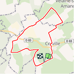
Cerville

ZAMBAUX
User

Length
8.7 km

Max alt
285 m

Uphill gradient
109 m
Km-Effort
10.1 km

Min alt
229 m

Downhill gradient
111 m
Boucle
Yes
Creation date :
2019-04-27 09:34:55.519
Updated on :
2019-04-27 09:34:55.567
2h13
Difficulty : Unknown

FREE GPS app for hiking
 SityTrail
IGN / Geographical institutes
SityTrail Plus
The world is yours!
About
Trail Walking of 8.7 km to be discovered at Grand Est, Meurthe-et-Moselle, Cerville. This trail is proposed by ZAMBAUX.
Description
Les 8 journaux
Positioning
Country:
France
Region :
Grand Est
Department/Province :
Meurthe-et-Moselle
Municipality :
Cerville
Location:
Unknown
Start:(Dec)
Start:(UTM)
301810 ; 5396456 (32U) N.
Comments